
When an emergency situation arises and the pilot is unable to fly the aircraft, Garmin autoland is designed to take control of the aircraft and land it at the nearest suitable airport. Here’s how it works: The system constantly monitors the aircraft’s flight path and compares it to a pre-determined set of landing criteria. If the system detects that the aircraft is not on a safe flight path, or if the pilot is unresponsive, it will initiate autoland. Once autoland is initiated, the system will take control of the aircraft and fly it to the nearest suitable airport. The system will select the runway that is most appropriate for the aircraft’s weight and configuration, and will line the aircraft up for landing. The system will then lower the landing gear and landing flaps, and will control the aircraft’s speed and descent rate to ensure a safe landing. Once the aircraft has landed, the system will apply the brakes and bring the aircraft to a stop. In the event that the nearest suitable airport is not able to support the aircraft, the system will continue to search for alternate airports until a suitable landing site is found.
Garmin, Piper, and Cirrus are pleased to announce the launch of Autoland, a ground-based safety tool that will automatically land your plane. Garmin’s Autonomi suite of safety utilities includes this system. The Piper M600, the Cirrus SF-50 Vision Jet, and at least one other aircraft have been cleared for certification by Autoland.
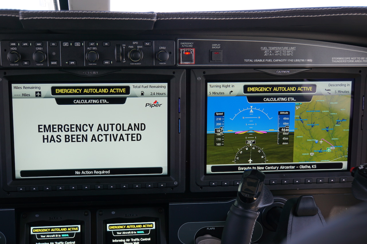
How Does The Autoland System Work?
The Autoland system takes control of the aircraft and configures the engine power settings to maintain the required approach profile while landing safely without the pilot’s intervention. The pilot must reduce thrust to idle when performing autoland in some systems.
It is critical to have an automated system in place on board to ensure the aircraft maintains a stable position. These landing aids are now common on most jets because they were developed to allow for bad weather landings. Pilots must remain in close contact with the autoland process at all times. Autoland employs a variety of systems as well as onboard equipment. This can be accomplished by using the same autopilot principles as the rest of the system. There are many (usually three) independent autopilot systems used in Autoland. Depending on whether the plane can control the nose wheel, it may or may not be able to land on the ground. It is up to the pilots to take over as soon as they land. In low-visibility or foggy conditions, an autoland is usually used, but in strong crosswinds, it is not.
Pilot Safety Is Paramount: Garmin Autoland Is The Future Of Emergency Landings
Garmin Autoland, a revolutionary new feature, allows pilots to keep their instruments in the air in the event of a runway emergency. The pilot is in complete control of the flight to ensure a smooth and safe landing. In the modern era, airlines around the world are using this technology to keep pilots safe.
What Is Garmin Autoland?
Garmin autoland is an automated landing system that is designed to land an aircraft in the event of a pilot incapacitation. The system is activated by the push of a button and will take control of the aircraft, guiding it to a safe landing.
Garmin’s Autoland allows passengers to get what they’ve always wanted. Autonomy, a state of being able to make decisions and act as sovereign unto oneself, is defined as a state of ability. If an autoland is used, the airplane can not only escape the immediate danger but also make it to the runway safely. Garmin and Piper Aircraft developed the Autoland system for light aircraft. The first flight in the research into Autoland took place in May 2014, after the research began in 2011. One engineer’s opinion is that wrapping our arms around what we really are was a difficult task. An autoland system detects a pilot’s lack of response by automatically turning off the engine or allowing the pilot or passenger to press a button.
Customers can fly the aircraft under Basic Med as long as the aircraft is not operational weight greater than 6,000 pounds and remains between 18,000 feet and 6,000 pounds. When a passenger presses Autoland on the plane, the program launches as soon as it is launched. Autoland protects the envelope, terrain, routes, and weather. When ESP is engaged for a long period of time, Autoland enters level mode. Furthermore, it can forecast weather for up to 15 minutes into the future. The ideal runway length for the M600 is 5,000 feet. Other runway conditions, such as rain, ice, and snow, must be taken into account as well.
Patel says the goal is to keep the jacket as comfortable as possible. Eric Sargent, Garmin’s flight-test pilot, informs me that I can tell you’re an instructor by the involuntary position of my hands below the yoke as we descended into the round out over the runway. We landed firm and secure on a slick runway, avoiding any surface tension rain that may have been left behind on the slick runway. Garmin’s Autonomi system was the inspiration for the Vision Jet’s architecture. Autoland perfectly fits in with Cirrus’ overall philosophy. Passengers should be able to use the safety feature if the pilot incapacitates. There will be an initial activation of Autoland at some point in the near future.
The training that pilots must undergo is critical to keeping Garmin, Piper, and Cirrus aircraft as safe as possible. The first use of Autoland was, essentially, three years after it was activated. After the pilot lost control of the aircraft, he deployed the parachute, saving one life.
Garmin’s New Autoland Feature: A Great Step In The Right Direction
Garmin’s new Autoland feature is an important step forward in ensuring safety. It is in charge of the plane’s flight in the event of a pilot’s unavailability to fly it. The main advantage of this is that it reduces the risk of a crash for commercial aircraft. However, there are still a few limitations to the system. In addition, signals can be degraded by surrounding traffic by using calibrated ILS equipment, as well as by using accurate ILS guidance. As a critical safety feature, you should continue to use it whenever possible in your plane.
Why Isn’t Autoland Used All The Time?
Autoland is not used all the time because it is not foolproof. The system relies on a number of sensors and inputs to make decisions about when and how to land the plane. If any of these sensors or inputs fail, the system may not be able to land the plane safely. Additionally, autoland can be disrupted by bad weather, which may cause the plane to land unsafely.
When Can Autoland Be Used?
A standard runway can be used on any suitably approved instrument landing system (ILS) or microwave landing system (MLS) approach, with the runway also being used to maintain currency of an aircraft and crew during an emergency landing in poor visibility or bad weather.
The Autopilot: A Vital Safety System For Aircraft
Depending on the terrain, it is possible to land at high altitudes using the autopilot. It is the autopilot’s job to maintain the aircraft’s speed and altitude, as well as to avoid any potential hazards on the ground. It is critical for the aircraft’s safety system that the autopilot is used; it can assist the pilot in ensuring that flights are carried out smoothly and without a hitch.
Do Pilots Usually Use Autoland?
An Instrument Landing System (ILS) is used by approximately 1% of all commercial flights. To fly with ILS, crosswinds of less than 46 km per hour must be allowed, comparable to a strong breeze, and visibility conditions in fog can be difficult.
Pilots Rely On Automation To Land In Difficult Conditions
While manual landings are still common, automated landings enable pilots to land in more difficult conditions and fly with greater precision. The pilot employs a variety of sensors, including weather radar and GPS, to make informed decisions while landing.
Do Pilots Use Ils All The Time?
The use of ILS is at the discretion of pilots with authorization from the Federal Aviation Administration. Even if the landing is not ILS, the ILS localiser and glideslope can still be used as a reference during a visual approach. It is the pilots’ decision whether to fly on the glideslope or the visual indicators.
Ils Can Be Helpful But Isn’t Always Reliable
Pilots can use the ILS to guide them when visibility is poor or when it is cloudy. When the pilots only see a few seconds of the runway before taking off, it allows them to fly the aircraft all the way to it. The ILS is, however, not always the most dependable method for landing.
Garmin Autoland Experimental
The Garmin Autoland system is an experimental system that is designed to automatically land an aircraft in the event of a pilot incapacitation. The system is designed to be used in conjunction with an autopilot system, and uses GPS data to identify a suitable landing site. The system has been tested in a number of simulated scenarios, and is awaiting certification from the FAA.
Do Airlines Use Autoland?
The autopilot system on the plane enables it to land on its own. While pilots monitor the aircraft’s systems, the autopilot is programmed to perform the landing automatically.
Garmin Autoland Cirrus
Garmin autoland is an amazing feature that allows your airplane to land itself in the event of an emergency. This is a great feature for those who may not be able to land the plane themselves.
Cirrus Sf50 Vision Jet Crash Highlights Importance Of Pilot Familiarity
The Safe ReturnTM emergency autoland system is a new addition to our suite of safety features that makes it easier than ever to land the Vision Jet on a runway in an emergency. Since 2016, when Cirrus Aircraft certified the SF50 Vision Jet, a single-engine jet with a type rating, there has been little controversy. Many new pilots at the time were not familiar with or qualified to fly the aircraft. The crash of a Cirrus Vision Jet on Friday, which killed all three people on board, raises important questions about the aircraft’s sophisticated and powerful design. Before a pilot can fly a plane, they must first be familiar with its capabilities. Have we ever seen a Vision jet crash? On Friday, the Cirrus SF50 Vision Jet was heavily damaged when it crashed while approaching the Kissimmee Gateway Airport (KISM) in Orlando, Florida. It departed from the company’s headquarters in St. Cloud, Minnesota, and arrived in Kissimmee shortly before noon. The National Transportation Safety Board (NTSB) is in charge of investigating the crash.
Garmin Autoland Certification
As of October 2020, Garmin is the only company to offer an FAA-certified autoland system for general aviation aircraft. The system, called the Garmin Autoland, is available on select models of the Garmin G3000 integrated flight deck. The system is designed to automatically land an aircraft in the event of a pilot incapacitation, and can be used in both VFR and IFR conditions. The system includes a dedicated autopilot, autothrottle, and flight director, as well as an emergency descent mode and a GPS-based approach and landing database.
Garmin Autoland was recently certified as an FAA General Aviation Aviation Part 135. If an emergency arises, the aircraft will be controlled and controlled without the need for human intervention. The Garmin Autoland system is also featured on the Cirrus Vision Jet and Daher TBM 940. The Garmin Flight Deck includes tools and capabilities such as Autoland, Emergency Descent Mode (EDM), and Electronic Stability and Protection (ESP) that make it easier to stay safe. EDM’s ability to automatically descend aircraft to a predetermined altitude without the use of pilot intervention allows it to reduce the risk of hypoxic situations. ESP is activated while the pilot is hand flying the aircraft to aid in the avoidance of unintentional flight attitudes or bank angles. Garmin offers a diverse range of navigation, communication, flight control, hazard avoidance, and an expansive suite of ADS-B solutions. Since the invention of its first GPS navigation device, Garmin has pioneered new GPS navigation and wireless devices and applications aimed at people who are active. Garmin is a provider of products and services to five primary markets: automotive, aviation, fitness, marine, and outdoor recreation.